Simulating an Entire City Undergoing an Earthquake
K computer achieves unprecedented accuracy in simulating quake damage, revealing a number of unanticipated results
Simulating an Entire City Undergoing an Earthquake
K computer achieves unprecedented accuracy in simulating quake damage, revealing a number of unanticipated results
Professor of Earthquake Research Institute, The University of Tokyo
Leader of the Computational Disaster Mitigation and Reduction Research Unit, RIKEN AICS
Upon graduating from university as a civil engineering major, Hori had originally planned to join a major construction firm. But he changed his mind and continued to work in the world of research, inspired by a Japanese scientist he encountered while studying at Northwestern University.
In the aftermath of the 2011 earthquake-tsunami that devastated the Pacific coastal areas of Tohoku in northeastern Japan, criticism arose concerning the lack of effective local and national government measures to cope with unexpectedly large tremors. The Tohoku tragedy taught us an important lesson: We need to know exactly what steps to take to prevent quake injuries and minimize damage.
Consequently, some in academia have put a priority on taking a scientific and rational approach to predicting the scale of damage possible. Hori, working with the K computer, has sought ways to integrate simulations that cover everything from how the ground and buildings move and shake, to how residents are evacuated, particularly in urban areas. In the following interview, he comments on the results of his research and how they can help further investigations.
Humans, Hori pointed out, have been building structures for thousands of years. Yet it was not until around the time of the Great Kanto Earthquake of 1923 in Japan that scientific investigation into earthquake damage to structures began to be widely investigated around the world. In the years that followed, the concept of horizontal quake acceleration was applied in the design of buildings.
Then in 1940, knowledge of seismic waves measured during earthquakes was employed in structural design for the first time, in the United States. In subsequent years, earthquake engineering constantly improved and quake-resistant design grew in importance.
Seismic wave data are now widely accepted as an important tool for designing quake-resistant structures. A modeled structure is subjected to earthquake simulations, and numeric data are collected on how the model shakes and which sections are most heavily affected.
But a city has so many structures that it is impossible to model or simulate all of them despite the increasing importance put on predicting earthquake damage. So how are local governments estimating possible damage?
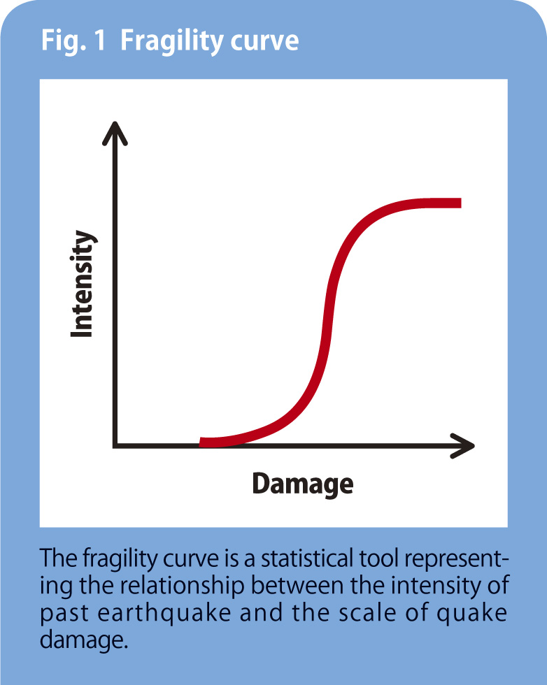
“They’re drawing on the experience of past earthquakes and predicting damage with the aid of a fragility curve that depicts relationships between the intensity of earthquakes and actual damage,” says Hori (see Fig.1).
“Structures based on old architectural quake-resistance standards can more easily collapse,” he notes, “which means that as long as past experience is the primary tool of prediction, presumed damage will be much greater than actually occurs in cases where modern building standards have been employed. This is far from being a reliable forecasting method. Yet the simple fact is, no other means have been available.”
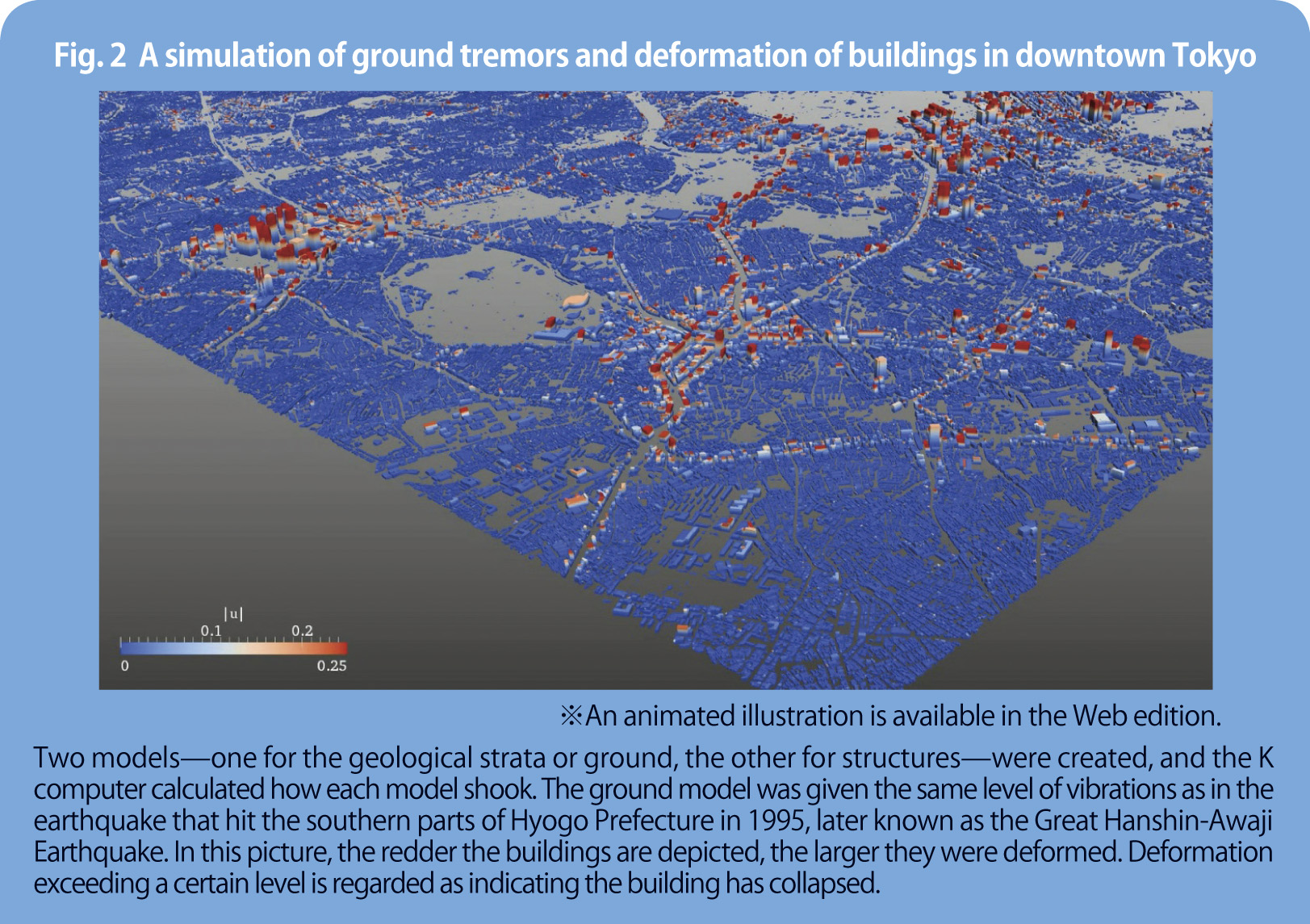
So Hori and his team decided to simulate an entire city and subject it to tremors—a breakthrough method in earthquake-damage prediction. What enabled this previously impossible task to be carried out is the huge computing power of K computer. The team used the supercomputer to reproduce the different ways an earthquake causes the earth to move and structures to shake and slide (see Fig. 2).
To do this, they simulated an area—8 km east to west and 7.5 km north to south—of downtown Tokyo, which is a heavily built-up area with more than 250,000 buildings and houses. Three-dimensional models of all these structures were created, based on data from a cartographer. Each of the three geological strata beneath the area—clay, sand and bedrock—were also modeled, using data from the Japan Geotechnical Society.
Hori’s group applied vibrations as strong as those measured during 1,000 actual earthquakes in the past to the geological model, and computed the ways the structures shook. This approach proved very useful and a big step forward in gauging the size of damage, that is, in identifying vulnerable structures by the strength and type of earthquake.
Says Hori, “Once we establish an effective scientific and rational means of damage prediction, it will help us set priorities in working out overall anti-disaster measures. And applying a wider variety of different quake vibrations to the models will certainly contribute to reducing the number of ‘unanticipated’ situations.”
An animated illustration is available here.
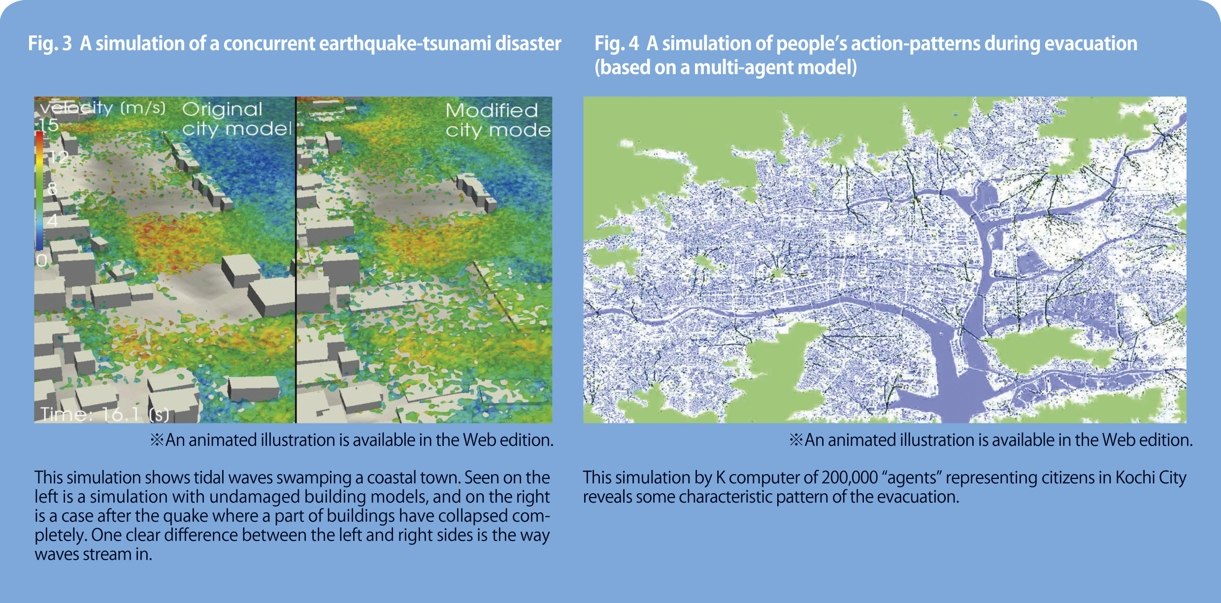
Earthquake damage is not limited to structures. The Tohoku disaster of 2011 triggered tsunami tidal waves that claimed a large number of lives. Such giant waves could accompany big quakes occurring in what’s known as the Nankai Trough, and would wreak havoc on affected areas.
With this in mind, Hori and his colleagues simulated a number of concurrent quake-tsunami disasters (see Fig. 3). “We used ground and building models similar to those created for the downtown Tokyo project, then simulated the motion of a tidal-wave by employing a particle method,” he explains (see Note 1). “Results indicated that buildings whether collapsed or not determine the direction of sea-water inflow.”
The scale of a disaster is also determined by how orderly residents are evacuated. Using the K computer, Hori simulated how some 200,000 citizens from Kochi City on the island of Shikoku would be evacuated to the surrounding hills (see Fig. 4). This simulation called for the employment of a multi-agent model among others (see Note 2), which Hori believed would produce more realistic images.
“We based our calculations on the assumption that evacuating residents would produce some identical pattern of movement—they would decide for themselves in what directions to flee and would slow down when they were about to run into other people escaping,” says Hori. Results of this simulation will help greatly in determining evacuee-guidance procedures and the installation of related road signs and guidance information.
Hori’s group have devised separate analysis models and computing procedures for ground-building movements, tidal waves and resident evacuations. Diverse data necessary for conducting these analyses have now been collected. But Hori is looking even further ahead. “The next major step is to integrate all these components,” he says, “so that we can conduct a greater range of calculations with the goal of establishing simulations that produce data closer to reality.”
Note 1 : The particle method, depending on what is being calculated, simulates the motion of interacting particles such as water-drops, molecules, etc. to track, for instance, the complicated movement of surface water. Hori employed a method normally used in computing the motion of stars.
Note 2 : The multi-agent model aims to simulate interactions between people, where each person is viewed as an agent that acts according to a particular rule.
An animated illustration is available here.
An animated illustration is available here.
Hori is also currently engaged in applying newly developed programs for structure modeling and computation to the anti-disaster projects of Kobe and other municipalities in Hyogo Prefecture.
“Thanks to the detailed structural data provided by the Kobe City government, simulations based on models more accurate than for downtown Tokyo will be possible,” says Hori. “Once a scientific and rational tool is readily available, other cities than Kobe will provide us more detailed data, and this will increase simulation accuracy.”
Hori is moving ahead with yet another ambitious plan: He wants Japanese universities to use the K computer-developed programs on their supercomputers. “Predicting quake damage should be conducted for all regions,” he argues. “Even though it’s impossible to perform the same level of computation in terms of scale as K computer, university supercomputers are still competitive in terms of accuracy if the area to be modeled is reduced to, say, one-tenth. And if university machines are used strategically in this way, scientific and rational damage prediction can be possible on a regional basis.”
Such comprehensive simulation for preventing and minimizing earthquake disaster has only just begun. Hori, always looking to push the boundaries of supercomputing, will no doubt continue to lead in this field for some time to come.