


We aim to develop and conduct large-scale numerical simulations of multi-hazard natural disasters, including earthquakes, tsunami, floods, landslides and mud slides.
Simulation of a natural disaster that can devastate an existing city requires the representation of existing buildings and infrastructures as equations and numerical data. These equations and data are defined as numerical city structure models. Cities have many kinds of structures. They are made up of, not only buildings whose design drawings are available, but also, for example, subway systems, domestic water and sewage pipes, and artificial river banks. We are developing cutting edge technology to represent these complex city components in numerical simulations.
We also aim to create large-scale numerical simulations of geotechnical hazards like liquefaction and slope failure because the underground conditions that produce such hazards is not well understood. We have developed efficient and manageable numerical methods to help us simulate such geotechnical hazards.
By combining these advanced simulations with seismic simulations and meteorological simulations, we aim to produce multi hazard simulations. We believe our research results will benefit citizens and governments alike, and will help create resilient societies.
Recent Achievements
Hazard map based on large-scale simulations
We have developed a next-generation hazard map depicting a possible scenario resulting from the predicted Nankai Trough Earthquake. Using large-scale numerical simulations, it includes four cities in Hyogo prefecture.
Previously, hazard maps were made from the results of simpler numerical simulations and empirical equations based on distribution of ground motion index values. However, the latest simulations using the K computer for next-generation hazard maps simulate propagation and amplification of seismic waves, and then calculate their physical impact on buildings. In other words, the latest simulations explicitly calculate the fragility curve. This calculation is an essential component for estimating damage to cities from earthquakes because the simulation includes the elemental physical process of the propagation of waves and the response of buildings to these waves.
Our numerical simulation developed to create next-generation hazard maps has two advanced features. The first is the comprehensive simulation of an entire city 100km2 in area. Comprehensive simulation means both geotechnical wave propagation and urban structures have been simulated simultaneously. This large-scale comprehensive calculation is performed on the K computer. This achievement resulted in the technology being chosen as a finalist for the Gordon Bell Prize. The second feature enables the technology to represent existing buildings in numerical simulations as data and equations. By using newly developed automated translation techniques, hundreds of thousands of buildings can be represented in such simulations.
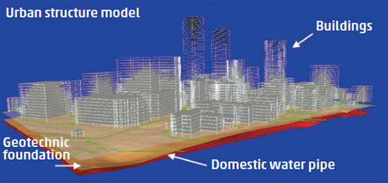
Numerical city structure model